|
|
| ~ South Tancolunda Bay - Huatulco, Mexico! ~ |
~
Stunning Beaches ~
Stroll across soft sands and gaze out across
crystal clear blue waters of the Pacific Ocean on Huatulco's beaches. Many of them have bars and restaurants
on them, so you can spend time sun bathing, swimming, snorkeling... and return to a choice and variety of restaurants and
bars to quench your thirst and provide great tasting food to set you up for your afternoon's water activities!

~ Beaches of Bahía Conejos, MX ~
[Conejos Bay: is located East of Tangolunda Bay]
Playa Tejonito: (badger) • Located at the western edge of Conejos Bay, 300' gently sloping beach, calm waves, shallow depth.
For swimming, snorkeling, diving, and fishing. Accessible
by boat. Seafood and sodas available during the busy season.
Playa Arena:
(sand) • Located east of Playa Tejoncito,
300' long, sloping beach with strong waves. For swimming, snorkeling, diving, and fishing.
Accessible by boat. Seafood and sodas available during
the busy season.
Playa Punta Arena:
(sandy point) • East of and adjacent to
Playa Arena and centrally located in Conejos Bay. About 1/2-mile long, sloping beach with
strong waves, not recommended for inexperienced swimmers. Accessible by boat. Seafood and sodas available during the busy season.
Playa Conejos:
(rabbits) • At the eastern end of Conejos
Bay, 1/4-mile long, fine white sand, shallow out to 50' from shore, then having rocky formations.
~ Santa Cruz area Beaches ~
Playa La Entrega:
(the surrender)
• This beach is where the Italian sailor Francisco Picaluga betrayed General Vicente Guerrero.
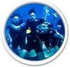
The 600' beach is the southernmost of the Santa Cruz beaches and is good for swimming and diving.
Wave action varies from calm to moderate at different places along the beach. Accessible by land and boat.
Playa Yerbabuena:
(mint) • This small, quiet
beach is located on the western shore of Bahía de Santa Cruz, north of Playa La Entrega. Accessible
by boat. Moderate waves.
Playa Santa Cruz:
(cross)
• Located in Santa Cruz, this 800' long beach features calm waters, coral, sea shells,
and lots of fish life. A good place to snorkel or scuba, but watch out for sea urchins
and moray eels. Small underwater cave. Restaurants,
equipment rental, and boat rides available.
Playa Chahue: •
2000' long, sloping beach with moderate waves located east of Santa Cruz. For experienced
swimmers.
Playa Esperanza: (hope) • 400' long, strong waves, east of Playa Chahue. Not
recommended for inexperienced swimmers.
Playa El Tejón:
(badger) • 400' long with moderate waves, located east of Playa Esperanza.
~ Tangolunda Beaches: ~
Playa Consuelo:
(consolation) • A small, 250' beach with
moderate waves west of Bahía Tangolunda. Accessed by boat.
Playa El Arrocito:
• A small, 300' beach with small waves and shallow depth located just west of Bahía Tangolunda.
Accessed by boat.
Playa Ventura, Playa Manzanillo
(apple), & Playa Tornillo (bolt)
• These three beaches are located together on the western shore of Bahía Tangolunda at
the Club Med. They total about 600' in length with calm waves. Good
for swimming, snorkeling and all aquatic sports.
Playa Tangolunda: •
The Sheraton, the Maeva, and the golf course are located on this 1/2-mile long beach. The beach may also be accessed through Tangolunda Park, west of the hotels. Moderate
waves. Swimming, diving, and all watersports available.
Playa Rincón Sabroso:
(pleasant corner) • Located west of Tangolunda,
800' long, moderate waves. Swimming snorkeling and all aquatic sports.
Playa La Mixteca:
(name of an indian tribe) • Small beach
near the mouth (east side) of Tangolunda Bay
~ Beaches west of Santa Cruz, MX ~
Playas Cuatonalco, Boca
Vieja, Ixtapa, Coyote: • These beaches all have similar characteristics.
They are more than 10 miles from Santa Cruz by boat. To reach
Cuatonalco and Boca Vieja (old river mouth) by land, follow the dirt road that intersects the coastal highway (200) at the
Rio Coyula bridge 4 miles west of the Huatulco airport. To reach Ixtapa and Coyote, take
the dirt road that intersects the coastal highway at the same point as the road to Santa María Huatulco which is just west
of the airport. The beaches face directly on the ocean. Each
beach is about a mile in length with sloping fine white sand, and strong waves. Not recommended
for inexperienced swimmers.
Playa San Agustín: •
About 1-mile long, calm waves, gentle slope, shallow depth, much coral, restaurants serving fresh
seafood. Excellent for snorkeling and diving. Accessible
by land by taking the dirt road that intersects the coastal highway at the same point as the road to Santa María Huatulco
which is just west of the airport, or by boat from Santa Cruz.
Playa Cacalutilla:
• Located in San Agustín Bay northeast of Playa San Agustín, 700' long, gently
sloping, shallow depth. Excellent for snorkeling. Accessible
by land by taking the dirt road that intersects the coastal highway at the same point as the road to Santa María Huatulco
which is just west of the airport, or by boat from Santa Cruz. Swimming, snorkeling, diving,
fishing, water skiing.
Playa Chachacual:
• 3/4-mile long, sloping beach, moderate waves, accessible by boat. Not
recommended for inexperienced swimmers. Swimming, snorkeling, diving, fishing.
Playa La India:
• Located in Cchachacual Bay, 1/4-mile long, fine white sand, accessible by
boat. Swimming, snorkeling, diving, fishing.
Playa Jicaral:
(cuplike) • Located
west of Chachacual Bay, 150' long, moderate waves, fine white sand moderately sloping with small rocky formations. Swimming, snorkeling, diving, fishing.
Playa Riscalillo:
• Fine white sand, gentle waves, shallow depth. Swimming, snorkeling, diving,
fishing. Access by boat, located 30 minutes southwest of Santa Cruz
Playa Cacaluta: (black eagle) • About
1/2-mile long, coarse white sand, strong waves, accessible by boat. Swimming, snorkeling,
diving, fishing. 300' offshore is Cacaluta Island: A
small rocky island, around which divers can explore coral reefs at depths to 80'.
Playa Maguey: •
1/4-mile long, accessible by boat and land, calm waves on the east end, moderate on the west end. Good
swimming and snorkeling. Further out, Punta Maguey
is good for scuba diving with walls and caves.
Playa Organo:
(organ cactus) • 800' long, moderate waves,
accessible by boat, land access is difficult. Swimming, snorkeling, diving. Seafood and sodas available during the busy season.
 |
![S. Tancolunda Bay: [Photo should be Shown]](/imagelib/sitebuilder/misc/show_image.html?linkedwidth=actual&linkpath=http://www.virtual-travel.info/sitebuildercontent/sitebuilderpictures/south_end_tancolunda_bay.jpg&target=tlx_new)
